
Trouvez la réponse à votre question grâce à la Foire aux Questions des utilisateurs du site.
The features of the website viarhona.com are numerous. You can:
• Create your own itinerary using the route planner.
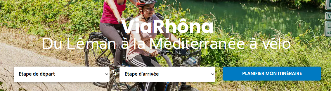
- Add to your itinerary the tourist services that interest you (accommodations, bike rentals, visits, activities…).
Import selected GPX tracks.
I- How to navigate (GPX tracks, maps, and guidebooks)?
1. How to get a ViaRhôna map?
You have three options:
- Get a paper ViaRhôna map from the various tourist offices located along the route and/or download them for free from https://www.viarhona.com/preparation/se-reperer/balisage
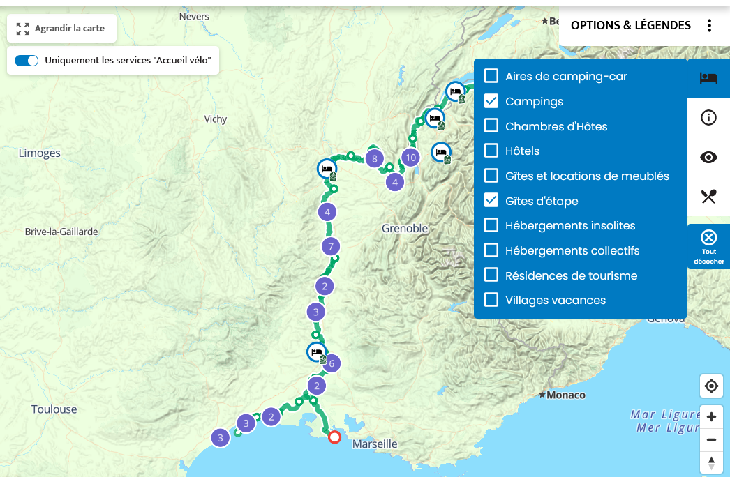
- Use the interactive maps of the 25 stages on the website.
Print the stage sheets including the map by clicking on the "PDF Sheet" button.
2. How to use GPX tracks?
The route is fully signposted with panels from North to South and in both directions, so a GPX track is not essential. However, despite the care taken in maintaining these panels, one may be missing, and having the GPX track can be useful.
You can download it to a connected device: hiking or cycling GPS, smartphone app, watch… For any information regarding its download, visit this page.
3. How to navigate the route without a GPX track?
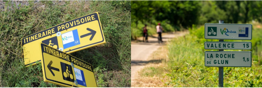
You just need to follow the directional signs that display the ViaRhôna logo, as well as city names and distances.

In the event that a sign is missing, here are some tips to find your way:
• By looking into the distance, you can sometimes see the next sign.
• If there is a sign in the opposite direction, try to understand where the cyclists are coming from in front of you, and you will likely find the logical continuation of the route.
• The route generally follows roads of the same type (main or secondary) or the same surface: try to understand this continuity to orient yourself.
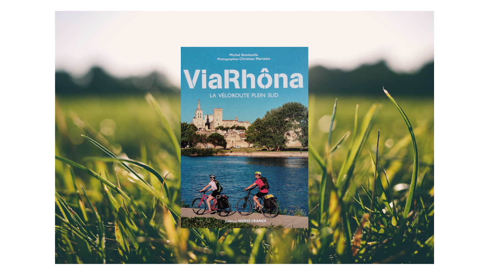
4. Are there guidebooks available?
Yes, several French and foreign publishers publish ViaRhôna guidebooks. You can find the references on this link.
II- Tourist services (accommodations, bike rentals, luggage transport, trains, picnic areas, water points, …)
1. Where to find accommodation, a restaurant, and other services?
Many services are available along ViaRhôna (accommodations, restaurants, etc.). When they are located within 5 km of the route and labeled Accueil Vélo, they appear by default on the interactive maps of the 25 stages.
You can make all services along the route appear by unchecking the "only Accueil Vélo services" slider at the top left of the map.

2. Is it necessary to book accommodation in advance?
It depends on the type of accommodation you choose and the time of year. For hotels, bed and breakfasts, inns… it is generally necessary to book. For campsites, it is often possible to go at the last minute. However, for all types of accommodation, it is strongly recommended to book in advance during the summer.
3. What does the Accueil Vélo label mean?
It is a quality label that allows you to identify tourist providers adapted to bicycle tourism. Tourist providers can be accommodation providers, bike rental or repair shops, tourist offices, restaurateurs, or sites of visit or leisure. They are located within 5 km of ViaRhôna and offer a number of specific services for bicycle travelers.
Link to "Accueil Vélo" accommodations along the route.
4. How to book an All Inclusive trip?
Many tour operators offer all inclusive trip. They take care of booking your accommodations, transporting your luggage, and if necessary, providing you with a rental bike! Find the offers here!
5. Can you transport your bike on the train?
Yes, it is possible, but only on certain trains! For example, most TER trains are equipped to transport bikes without dismantling them, which is not the case for TGVs. Moreover, 36 stations serve the route. For more information, you can visit our page How to get there and return?
6. Can you easily take breaks along the route?
It is quite possible to stop along the route, for example at service areas or rest stops. Some are equipped with picnic tables, water points, toilets, and bike parking. Find them on the interactive maps of the 25 stages. You can also stop freely to discover the local flora and fauna.
7. Where to find water points?
Numerous water points are available along ViaRhôna. To know their location, select "water points" in the legend of the interactive maps: they will then appear on the map. However, during certain periods of drought, these water points may be closed due to restrictions. Always carry a minimum amount of water with you, otherwise, do not hesitate to ask in the many bars and restaurants along the route, or at tourist offices, bike rental and repair shops, or sites of visit.
8. Is it possible to transfer my luggage?
Because traveling light allows you to enjoy your trip more serenely, luggage transfer is a service offered on certain stages of ViaRhôna. Transport companies offer to transfer your luggage, feel free to contact them!
9. Can you bivouac on ViaRhôna?
Bivouacking involves setting up your tent at sunset and leaving the next morning before sunrise, without leaving any trace of your passage. This practice is highly regulated and only possible if you have the permission of the landowner (Article R111-32). Before any bivouac, we advise you to inquire at the local tourist office.
III- Amenities (paving, signage, construction)
1. Where to find information on the route's amenities?
Some sections of ViaRhôna are under construction or on provisional routes that need better security. The goal is to complete the infrastructure over the coming years.
Information on the progress of each stage is presented in the descriptions of the stage pages, as well as through a color code on the maps.
The different types of routes (greenways, shared roads...) are explained on this page.
2. Is there signage along ViaRhôna?
The ViaRhôna cycling route is signposted from Lake Geneva to the Mediterranean with the route's logo, accompanied by the EuroVelo 17 emblem. When a provisional route is in place, the ViaRhôna logo is in black and yellow. Provisional sections are shown in red on the interactive maps of the stages.
3. What are the different pavements on ViaRhôna?
The pavement of the route varies from stage to stage. It mainly consists of paved and asphalt roads, and in some places, stabilized compacted gravel. You will find details at the beginning of the description of each stage page.
IV- Preparing your trip
1. What type of bike for ViaRhôna?
The type of bike depends on the use you intend for it. A hybrid bike, a touring bike, or a gravel bike will do very well. The pavement does not require a mountain bike, however, in some places, it is not suitable for road bikes.
2. Is ViaRhôna traveled from North to South or South to North?
ViaRhôna can be traveled and is signposted in both directions. However, from Lyon, it is advisable to head towards the sea, as the mistral wind can blow from North to South in the Rhône Valley.
3. What is the best time to travel ViaRhôna?
ViaRhôna has the advantage of being practicable almost all year round, by adapting your location. The northern part will be very pleasant in mid-season and summer, while July and August are the hottest months south of Lyon. Conversely, it is pleasant to discover ViaRhôna between Lyon and the Mediterranean during the off-season. And on a beautiful sunny winter day, it will even be possible to explore the coast if the wind is not blowing!
4. How can we return to the starting point?
36 stations are at your disposal to return with your bike: do not hesitate to consult the dedicated page, regularly updated.
5. Can anyone practice ViaRhôna regardless of their fitness level and age?
Yes, ViaRhôna is open to all levels, including children. You will encounter some climbs and descents in the first 80 km starting from Geneva. After that, the route is flat. The elevation changes are indicated in the stage sheets. Note that anyone in normal physical condition can easily cover 40 km per day.
For family rides, some tips are provided on this page.
6. I have a trailer, a recumbent bike, a tandem, or a hand-bike: are there any impassable barriers on ViaRhôna?
The greenways are now designed not to block the use of trailers and other special-sized bikes (staggered barriers or absence of barriers). However, some older installations (bollards) still exist, which we are working to replace gradually. If you encounter difficulties, we invite you to send a message on our Facebook page or on the feedback page for each section of the route.
With your collaboration, we will make ViaRhôna a cycle route accessible to the greatest number!
7. How to discover other routes starting from ViaRhôna?
ViaRhôna is a European cycling route that structures the territories it crosses.
From ViaRhôna, it is possible to discover other cycling loops, so do not hesitate to explore them!
For any other questions, feel free to ask the ViaRhôna user community on our Facebook page.